
Finding Who Lives Along Murray Streets
Walk an address in a fixed order. First, enter the street and number into the Salt Lake County Assessor advanced query. Next, open the parcel in the county GIS viewer and note adjacent polygons. Then read the recorder summary, check the official voter channel where lawful, and use a historical reverse directory if the question reaches back in time. This creates a street directory trail without treating one result as proof of current residence.
- Write down the exact street spelling, direction, number, and ZIP.
- Match the address to a parcel and legal description.
- Browse the map outward to nearby parcel IDs.
- Compare owner, mailing, voter, deed, and permit fields.
- Save the source date and ask the custodian about any conflict.
A street directory search can establish ownership clues and address history. It cannot reveal every occupant, utility customer, unlisted household, or protected participant. When the goal turns from one street to one person, the Murray resident lookup workflow is a better fit.
Murray Street Directory Records, Side by Side
Each record set answers a different question. The assessor is a parcel and ownership source. GIS supplies geometry and layers. The recorder supplies named parties and documents. Voter access is controlled and person-centered. Murray permits and code files are address-based but have no verified public search form. A useful street directory states the key and the limit for each source.
| Record set | Keeper | Street clue | Access |
|---|---|---|---|
| Property roll | Salt Lake County Assessor | Owner, situs, mailing, value | Free web search |
| Parcel map | Assessor GIS | Frontage, adjacent parcels, layers | Free viewer |
| Deed index | Salt Lake County Recorder | Grantor, grantee, dates, legal trail | Summary free, images paid |
| Voter record | Lieutenant Governor and County Clerk | Public fields and districts | Request and privacy rules |
| Permit or code file | Murray Building or Code Enforcement | Work, inspection, complaint dates | Call or GRAMA request |
Do not merge these rows. An owner may receive mail elsewhere, a voter may not own a parcel, and a permit applicant may be a contractor. A parcel number is the bridge between county systems, while a street name is the bridge to a human-readable address.
Murray Street Directory Field Notes
The advanced assessor screen is built for imperfect address data. It accepts an owner field, frontage number, direction, street name or number, type or direction, and parcel number. Owner names use last name, first name. Partial owner matching needs at least three letters. The search can combine an owner with a street number, direction, name, or type, or use just the frontage and street fields.
| Search field | Useful Murray entry | Reason to use it |
|---|---|---|
| Frontage number | Number before the street name | Separates nearby addresses |
| Dir. | Directional prefix or suffix | Distinguishes similar streets |
| Street name or number | Known street text | Finds a run of parcels |
| Type or direction | Street type or second direction | Refines the address |
| Parcel number | Full number or prefix | Anchors history and plats |
Record the result’s owner, parcel, property address, legal description, value, exemption, and map link. The county says its data may be at least 24 hours old and that a title search may be needed. That warning is especially useful when a street search is used for a deed or estate question.
Browse Murray Parcels in GIS
The Salt Lake County Assessor Parcel Viewer lets a researcher click from a known parcel to the polygons around it. County GIS materials describe parcel, address, city, ZIP Codes and Addressing, aerial, and related map layers. There was no verified promise of a single one-click resident list. Use the viewer to identify geography, then open each parcel’s record through the assessor or recorder.
A seven-digit parcel prefix has a local quirk. The first four digits represent an area or section, and the next three represent a block. Entering only that prefix can return the parcels on a block. Keep the full parcel number, legal description, and plat with the result because the prefix is a browsing aid, not a substitute for an address. A map can show adjacency without showing who occupies a building.
County GIS documentation explains the map route and related layers. The image below shows the advanced address approach that should precede a block browse.
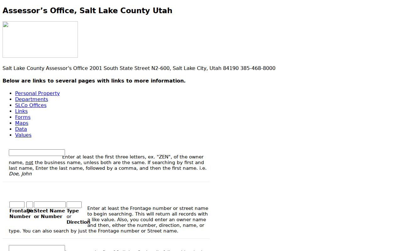
Use the visible fields to test spelling and direction variants before deciding that a street has no match.
Follow a Murray Deed Chain by Street
The recorder’s public search requires an address or parcel selection from an auto-populated list. A free summary can show current owner, property address, legal description, document count, document number, recording date, and document type. If the question concerns a past owner, open the latest deed or ask Recorder Data Services about images and chain functions.
Read grantor and grantee names, the recording date, instrument number, and legal description. Then search the prior grantee as a grantee to find the purchase before the current deed. Repeat until the index reaches a book, plat, or older layer that needs the county counter or Archives. Data Services advertises a $5 24-hour login, while ordinary document and plat fees vary by the published schedule. The Recorder’s contact page gives the office route and Property Watch information.
The Recorder contact page is the source for current office help. It is a useful safeguard when an index summary and a scanned instrument do not align.
A deed names parties to a transaction. It does not certify that a named grantee occupied the premises.
Permits Put Dates on a Murray Address
Murray’s Building Division can identify permits, inspections, certificates of occupancy, and site-plan records, but a public searchable permit index was not verified. Building hours are weekdays from 7:30 a.m. to 5 p.m., and permits are not received after 4 p.m. A GRAMA request should give the address, date range, and record type. The city’s GRAMA route is for existing records, not a request for staff to create a new history.
Older county material adds a longer view. Archives holds building-permit application cards from 1948 through 1969 with original owner, architect or designer, contractor, cost, and legal description. County permits cover about 1970 through 2019, with an incorporated-city caveat. Permit evidence dates work on a structure. It is not a list of everyone who lived there.
Voter Records Have a Legal Channel
Utah voter data can help test a name-and-address connection, but the public fields are limited. Full date of birth, Social Security number, driver or state ID, phone, email, and signature are not public. At-risk voters can have personal information withheld. The official status tool is at votesearch.utah.gov; a larger voter file follows the Lieutenant Governor’s request process.
Use this source as one corroborating layer. Do not copy a street list from a file, infer a household from a polling district, or treat a missing result as proof that someone moved. Election geography includes precincts, districts, and polling places, which are not the same as Murray’s parcels or ZIPs.
Reverse Directories on Old Murray Streets
Historical city directories can turn an address into a person for a particular year. The University of Utah Marriott Digital Library holds a Utah City Directories Collection that includes a 1910 Polk Salt Lake volume naming Murray. Later address-arranged or criss-cross pages can show the household or business at a street number. The Murray city directories page covers the collection method and companion sources in detail.
Address forms change. Tax rolls from 1853 through 1892 were arranged by ward and surname, then moved in 1893 toward legal description by plat and block. A modern street search can fail for an old resident if the researcher never checks plats, ward context, newspapers, or a legal description. Note the exact directory year and abbreviations before comparing it to a current parcel.
State Street, Rail, and Murray Addresses
Murray grew from South Cottonwood agriculture into a railroad and smelter town. The post office adopted the Murray name in 1883, and the city received recognition in 1902 and 1903. State Street and Highway 89, rail lines, trolley routes, the Jordan River, and Big Cottonwood Creek shaped where businesses and households appeared. That history helps explain why an old address may align better with a plat or newspaper than with a current map label.
Boundary records matter too. A December 2024 annexation notice near Van Winkle Expressway, 900 East, and 4800 South shows why a date-specific permit or zoning custodian may be needed. Check council notices, the assessor city field, plats, GIS, and USPS output together. A ZIP label alone does not settle a municipal boundary question.
What a Murray Street Directory Cannot Show
Public property records generally name owners or parties, not every person at an address. Utility customer data is not an ordinary public search. DMV address information is protected by the federal Driver’s Privacy Protection Act. Court, vital, voter, juvenile, sealed, expunged, and Safe at Home records can be restricted. Code complaints may withhold complainant details and other private information.
Lawful use. Use address records for personal research, family history, estate work, civic questions, and checking a record that affects you. Do not use a Murray street search to stalk, harass, intimidate, or harm a person. Ask the custodian how to correct an error or protect a qualifying record.
- Parcel
- A mapped county property unit.
- Situs
- The physical property address.
- Plat
- A recorded map that defines lots and blocks.
- Criss-cross directory
- A historical directory arranged by address instead of surname.